...
- In the Catalog pane on the right, expand the Databases folder.
- Expand the GeographicDistribution.gdb geodatabase.
- Right-click the USStatesPopTimeline feature class and select Add to New Map.
You may wish to zoom into the continental United States.
- In the Contents pane to the left, right-click the USStatesPopTimeline layer and select Attribute Table.
Notice that the attribute table contains population data every decade between 1790 and 2010 for each of the 50 states and the District of Columbia. These population counts include only people counted in the official US Census, meaning native populations and populations of territories, among others, are not included.
...
- For ‘Output Feature Class’, rename the feature class "USStatesPopTimeline_CentralFeature_1870".
- For ‘Weight Field,’ use the drop-down menu to select the Pop1870 field.
- Ensure your Central Feature tool parameters are configured as shown below and click Run.
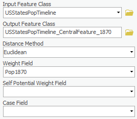
Result is Ohio.
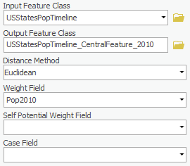
2010
- For ‘Output Feature Class’, rename the feature class "USStatesPopTimeline_CentralFeature_2010".
- For ‘Weight Field,’ use the drop-down menu to select the Pop2010 field.
- Ensure your Central Feature tool parameters are configured as shown below and click Run.
...