...
- In the Contents pane, click the IDW_Rain layer to select it.
- In the ribbon on the top, click the Appearance tab
- In the Effects group, adjust the Layer Transparency slider to 40% 30%.
Notice that you can now see the basemap beneath the raster layer.
...
- At the top of the Geoprocessing pane, click the Back arrow button.
- Within the 3D Analyst Tools toolbox, collapse the Data Management toolset.
- Within the 3D Analyst Tools toolbox, click the Conversion toolset > From TIN toolset > TIN To Raster tool.
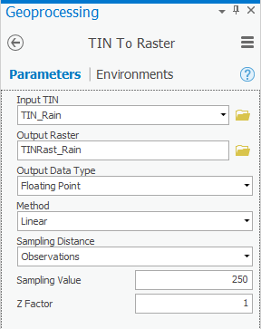
- For ‘Input TIN’, use the drop-down box to select the TIN_Rain TIN.
- For ‘Output raster’, rename the exported raster from “tin_rain_tin” to “TINRast_Rain”.
- Ensure that your 'TIN To Raster' tool Parameters tab appears as shown below and click Run.
- In the Contents pane, uncheck the TIN_Rain layer.
- Repeat the steps within the 'Inverse Distance Weighted Interpolation Method' section above to symbolize the TINRast_Rain layer as you did the other raster layers.
...
- In the Contents pane, check the Hurricane layer to make it visible.
- At the top of the Geoprocessing pane, click the Back arrow button.
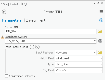
- In ArcToolbox navigate to 3D Analyst Tools toolbox > Data Management toolset > TIN > Create TIN.
- For ‘Output TIN’, type “TIN_Wind”.
- Use the ‘Input Feature’ drop-down box to select the Hurricane feature class.
- Use the ‘Height Field’ drop-down box to select the Windspeed field as shown below.
- Use the ‘Coordinate System’ drop-down box to select the Houses layer.
- Ensure that your 'Create TIN' tool Parameters tab appears as shown below and click Run.
...
- In the Toolboxes tab, collapse the 3D Analyst Tools toolbox.
- Click Spatial Analyst Tools > Extraction > Extract Multi Values to Points.
- Use the ‘Input point features’ drop-down box to select the Houses layer.
- Use the ‘Input rasters’ drop-down box to select all five interpolation rasters you created earlier one at a time: IDW_Rain, Spline_Rain, NN_Rain, TINRast_Rain and TINRast_Wind. The order in which the rasters are listed is the same order in which the extracted value columns will appear in the output feature class attribute table.
- Check Bilinear interpolation of values at point locations.
- Ensure that your 'Extract Multi Values to Points' tool Parameters tab appears as shown below and click Run.

...