...
- In the Contents pane, check the Hurricane layer to make it visible.
- At the top of the Geoprocessing pane, click the Back arrow button.
- Within the 3D Analyst Tools toolbox, collapse the Conversion toolset.
- Within the 3D Analyst Tools toolbox, click the Data Management toolset.
- The TIN toolset should already be expanded, but, if not, click the TIN toolset.
- Click the Create TIN tool.
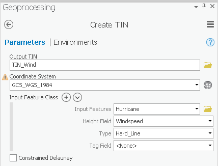
- For ‘Output TIN’, type “TIN_Wind”.
- For ‘Coordinate System’, use the drop-down menu to select the Houses layer.
- For ‘Input Features’, use the drop-down menu to select the Hurricane feature class.
- For ‘Height Field’, use the drop-down menu to select the Windspeed field.
- Ensure that your 'Create TIN' tool Parameters tab appears as shown below and click Run.
Again, you need to convert the TIN to a raster, so that it is comparable to the other interpolation layers.
...