...
There are three ways of obtaining the tutorial data. The best option for getting the full GIS project experience is to follow Option 1 and learn how to download data from online GIS data portals. You will also gain exposure to the best GIS data websites for the Houston region. If you have limited time or if any of the data provider websites are not functional, you may download an identical version directly from the computers in the GIS/Data Center (Option 2) or online from this wiki (Option 3). Follow the applicable set of instructions below depending on the particular computer you are using.
...
If you choose to download the tutorial data from the source websites and to practice finding and obtaining data from online sources, follow these the instructions :below.
H-GAC GIS Census Data
The Houston-Galveston Area Council (H-GAC) is the 13-county Metropolitan Planning Organization (MPO) for the Houston region. Federal legislation requires that an MPO be designated for each urbanized area with a population greater than 50,000 people (as established by the U.S. Census Bureau) in order to conduct long-range metropolitan transportation planning and be eligible for Federal funding for transportation projects. Their mission to carry out metropolitan transportation planning means that MPOs are a great source of data on topics such as demographics, employment, land use, transportation, and environmental conditions and most of these topics are well-suited towards GIS analysis.
Most of the data provided on the H-GAC portal is not originally created by the H-GAC. Instead, but rather the data is either aggregated from multiple municipalities up to the 13-country region, or clipped from the entire country or state down to the 13-county region. For this tutorial, we will download population and housing data from the 2010 census, which has been aggregated to census tract boundaries.
- Using a web browser, search for "hgac gis census data" and select the result as shown below or or go directly to: https://www.h-gac.com/census-data.

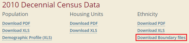
- Select "Under the '2010 Decennial Census Data' section, in the 'Ethnicity' column, click Download Boundary files" under the "Ethnicity" subheading.
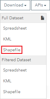
- Click the blue Download button.

- At the bottom of your browser window, you should see the "Download" from the top bar. We note that the data we are looking for is by census tract and can be seen under the list of files within the Census2010_Redistricting_Data_Shapefiles.zip we are downloading. compressed folder being downloaded.

H-GAC GIS Datasets
- Using a web browser, search for "h-gac hgac gis data" and select the result as shown below or go directly to: httphttps://www.gishub-h-gac.com/gis-applications-and-data/datasets.aspx

- Under the Browse Data by Category section, click the Transportation button to filter the results by subject.
- Scroll down and explore the available data, then click HGAC Major Roads, which should be at the end of the list.
- Click Download.
- Click Shapefile.
- hub.arcgis.com/.

- In order to see all of the data available in the catalog, click in the 'Search data' box and, without typing anything, press Enter.

Feel free to browse through the available data and filter by categories on the left. When you are finished exploring, you will download major roads data.
- At the top of the website, in the 'Search" box, type "roads" and click the HGAC Major Roads result directly beneath the search box.

- Click Download > Full Dataset Shapefile.
- At the bottom of your browser window, you should see the HGAC_Major_Roads-shp.zip compressed folder download.

Houston METRO Downloads
The Houston METRO website provides GIS data for the public transit system in Houston provided by METRO. While the same data is also available on the H-GAC Regional Data Hub, it is often For this tutorial, you will need the bus stops and bus routes data, which is included in the downloadable zip-file containing all of the GIS data available on the site. To obtain this data:
- Using a web browser, search for "houston metro gis" and select the result as shown below or go directly to: https://www.ridemetro.org/Pages/DigitalAssets.aspx.


- Scroll down to the bottom of the webpage and select Get Started.

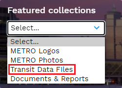
- From the left "Featured collections" dropdown select Transit Data Files.

- Select Shape files.
- Click on Bus Routes - shape file and click download.
- Repeat for Bus Stops - shape file.
...
OPTION 2: Accessing tutorial data from Fondren Library using the gistrain profile
| Anchor | ||||
|---|---|---|---|---|
|
If you are completing this tutorial from a computer in Fondren Library and are logged in using the gistrain profile, follow the instructions below:
- From the Start menu, click Computer > gisdata (\\file-rnas.rice.edu) (R:) > Short_Courses > Introduction_to_GIS_Data_Management.
- To create a personal copy of the tutorial data, drag the IntroTutorialData folder onto the Desktop.
- Close all windows.
OPTION 3: Accessing tutorial data online using a personal computerAnchor Option 3 Option 3
| Option 3 | |
| Option 3 |
If you are completing this tutorial from a personal computer, you will need to download the tutorial data online by following the instructions below:
...
Once you have downloaded the Bus Stops and Bus Routes data from Houston METRO and the Census and Major Roads data from HGAC, you should be able to find the data files in your Downloads folder. You will see that all the files are zipped, meaning they contain compressed files of data within them (you can tell a file is zipped when the file type column reads “Compressed (zipped) Folder”). You will need to unzip the folders to be able to see the data inside them. To do that:
- Open the Downloads folder.
- Ensure that you see the following zipped folders in your Downloads folder.
Census2010_Redistricting_Data_Shapefiles
HGAC_Major_Roads-shp
RS2688_Bus Stops - shape file
RS2689_Bus Routes - shape file
- Select all four folders.
- Right-click any of the selected folders and select 7-Zip > Extract here. If you do not have 7-Zip, you will need to right-click each file individually and select Extract all, then click Extract.
...