...
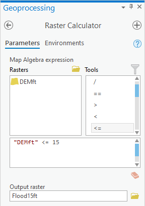
- In the Raster Calculator tool, delete the previous expression "DEMSubbasin" * 3.281.
- In the list of 'Rasters’, double-click the DEMft layer.
- In the calculatorlist of 'Tools', double-click the the <= button sybmol.
- In the equation box, type “15”.
- For ‘Output raster’, rename the raster from demft_raster to “Flood15ft”.
- Ensure your Geoprocessing pane appears as shown below and click Run.

- In the Contents pane, right-click the Flood15ft layer and click select Symbology.
- In the table of valuesSymbology pane, right-click the 0 value and click Remove.

- Click the rectangle symbol to the left of the 1 value and select Blue.

- Save your project.
...