...
Now you will calculate elevation statistics by watershed.
- Return to the Geoprocessing pane.
- At the top left of the Geoprocessing pane, click the Back buttonOpen Geoprocessing pane by clicking Tools from Analysis tab.
- In the search box, type "zonal statistics".
- Click the Spatial Analyst Tools toolbox, double-click the Zonal toolset then click Zonal Statistics as Table (Spatial Analyst Tools) tool.
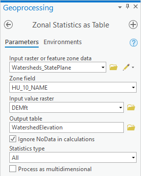
- For Use the ‘Input raster or feature zone data’ , use the drop-down menu to select the Watersheds_StatePlane layer.
- Use the For ‘Zone field’ drop-down menu to , select the ‘HU_10_NAME’ field.
- For ‘Input value raster, select the DEMft layer.
- For ‘Output table’, rename the table from “ZonalSt_Watersh1” to “WatershedElevation”.
- Ensure your ‘Zonal Statistics as Table’ window Geoprocessing pane appears as shown and click Run.

- At the bottom of In the Contents pane, right-click the WatershedElevation table and select Open.
This table tells you the statistics regarding all the elevation values within each watershed zone.
- In the Geoprocessing pane, search for ‘Table to Excel’"table to excel’.
- Click the Table To Excel tool.
- For the 'Input Table', select WatershedElevation from the drop-down menu.
- For ‘Output Excel File’, click the Browse button.
If you save this table inside your file geodatabase, you will not be able to open it outside of ArcGIS, so you will instead save it as a text file outside of your file geodatabase.
- Save the table within the HydrologyLab Locate and double-click the HydrologyLab folder to save the file within the folder.
- For ‘Name’, name as “ type “WatershedElevation”.
- Click Save.
- In the ‘Table to Excel’ windowGeoprocessing pane, click Run.
- Close the Table WatershedElevation table.
Now you will open the exported text file in Excel.
- Open Using File Explorer, open your WatershedElevation.xls spreadsheet in Microsoft Excel.
- Delete the OBJECTID, ZONE_CODE, COUNT, AREA, and SUM fields.
- Highlight the minimum and maximum values in each column.
...