...
- In the Catalog pane, expand the Databases section.
- Right-click PlayMapping.gdb and select New > Feature Class.
- Name it "HSTPoints".
- Under the Feature Class Type drop-down box, select Point.
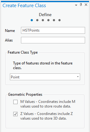
- Click Next twice.
- In the Spatial Reference section, under the Layers section, select the NAD 1927 projection.
- Click Next twice again.
- Click Finish.
- If the new feature class did not automatically iadd to your map: From the Catalog pane in the Databases section, expand PlayMappping.gdb. Right-click HSTPoints and select Add to Current Map.
- In the Contents pane, right-click HSTPoints and select Attribute Table.
- From the top of the attribute table, next to the Field: section, click the Add button.

- A new Fields view table appears. In the third row of the Field Name column, type "Thickness".
- Change the Data Type to Short Integer by clicking the drop-down box then selecting Short.
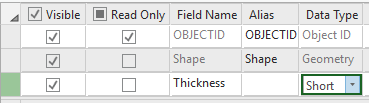
- From the Ribbon, in the Fields tab, click the Save button.
- Close the Fields view table by clicking the X at the top right corner of Fields: HSTPoints.
- From the Ribbon, select the Edit tab.
- From the Edit tab, in the Features group, click Create. A new pane, Create Features, opens on the right side of the screen.

- From the Create Features pane, click HSTPoints and select the Point button (first in list).

- In the Map View, click to add a point on the topmost left point displayed on the HST.jpg.
- In the Attribute Table, a new row has been generated for this newly created point. Click in the Thickness cell for this row and type "7".
- Repeat steps 19 and 20 for all points on HST.jpg.
- From the Edit tab, in the Manage Edits group, click Save.
- Click Yes for the 'Save all edits?' pop-up window.
- In the Edit tab, navigate to the Selection section and click the Clear button to unselect any points.
- Close the Create Features pane.
- Close the Attribute Table.
- Above the Ribbon, on the Quick Access toolbar, click the Save button.
Interpolation
This sections steps through how to interpolate a raster surface from points using a natural neighbor technique. For more practice with Interpolation, check out our short course: Data Interpolation and Extraction. For more information on Natural Neighbor Interpolation in ArcGIS Pro, check out this tool reference: Natural Neighbor (Spatial Analyst)
...