...
All GIS data is created in a particular geographic coordinate system used for mapping locations on a three-dimensional sphere, based on measurements of latitude and longitude. In addition, much GIS data has already been projected onto a two-dimensional plane, based on linear measurements, such as feet or meters. In order for ArcGIS to position a data layer in its proper geographic location, it must be told the proper coordinate system and projection in which the data was originally created. Otherwise, the data layer can be displayed as an image of sorts, but the image will not necessarily line up correctly spatially with other data layers in the map.
Determining
...
If Layers
...
Are Defined
In some cases, the geographic coordinate system and projection of the data has already been defined in ArcGIS, while, in other cases, you will need to define it yourself based on metadata obtained from the source of the data. First, you will need to determine whether or not each feature class has already been defined.
- In the Catalog pane on the right, expand the Databases folder.
- Expand the Projections.gdb geodatabase.
- Click the County feature class to select it.
- Hold down Ctrl and click the MajorRoads and Schools feature classes, so that all three feature classes are selected.
- Right-click the selected feature classes and select Add to New > Map.
- In the Contents pane on the left, double-click the MajorRoads layer name to open the 'Layer Properties' window.
- In the left menu, click the Source tab. Scroll down and expand the Spatial Reference section.
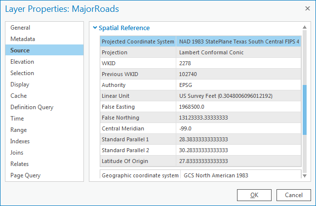
Under the ‘Spatial Reference’ section, scroll down and notice that both a geographic coordinate system and a projection are listed, which indicates that the coordinate system of this feature class has already been defined.
...
Whenever you encounter this type of situation, where two layers show up in the Contents pane, but do not line up as you expect them to, you know it is most likely a projection problem.
Determining
...
Projections for
...
Undefined Layers
Of the three feature classes you examined, the County feature class was the only one that was undefined. Since the spatial reference information cannot be located using ArcGIS, you must turn to the source of the data itself. The data was originally downloaded from the following website: http://www.esri.com/data/download/census2000-tigerline. A screenshot of the metadata provided on that website appears below.
...
If you are only interested in creating a visual map, as you have done now, then relying upon on-the-fly projection will suffice. If, on the other hand, you are interested in performing any sort of calculations between the layers that rely upon distance, area, or spatial overlap, then it is recommended that you use the same projection for all layers. In addition, you can only measure linear distances in a projected coordinate system, not in a geographic coordinate system, so the County layer would need to be projected anyway, before any sort of measurements could be made.
Selecting a Map Projection
Now that all of your data has been defined, you can transform all the feature classes into a common projection. Unlike the process of defining data, where there is only one projection you can use (the one specified in the metadata), when projecting data, you can select whichever projection best suites your particular combination of data and tasks at hand. Since your data focuses on the Harris County region, the State Plane Texas South Central projection would be suitable.
Determining
...
Which Layers to
...
Project
The State Plane Texas South Central projection has been selected for the final map projection. All layers that are not currently in that projection will need to be re-projected, such as the County and Schools feature classes. All layers that are already in the final projection can be left as is and do not need to be re-projected, such as the MajorRoads feature class.
Layer | Geographic Coordinate System | Projected Coordinate System | Matches Final Projection? |
MajorRoads | NAD 1983 | State Plane Texas South Central | Yes |
| Schools | NAD 1983 | Texas Centric Mapping System | No |
County | NAD 1983 | None | No |
Projecting Layers
- At the top of the Geoprocessing pane, click the Back arrow.
- In the Find Tools search bar, type ‘project’.
- Click the Project tool.
- For 'Input Dataset or Feature Class', use the drop-down menu to select the County layer.
...
Since all layers in your data frame are now in the same projection, you could proceed to make accurate calculations of distance and area between the layers.
...