...
- On the ribbon, click the Analysis tab.
- In the Geoprocessing group, click the Tools button to open the Geoprocessing pane on the right.
- In the 'Find Tools' search bar, type "define projection".
- Click the Define Projection tool to open it.
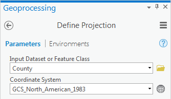
- Use the ‘Input Dataset or Feature Class’ drop-down menu to select County.
- For the 'Coordinate System', to the right of the drop-down menu, click the Select coordinate system button.
- In the Coordinate System window, expand Geographic coordinate system > North America > USA and territories.
- Click NAD 1983 and click OK.
- Ensure your Geoprocessing pane appears as shown below and click Run at the bottom of the Geoprocessing pane.
Notice that the County layer has been projected onto the correct location of Harris County.
- In the Catalog pane, double-click the County layer name.
- Select the Click the Source tab and expand the Spatial Reference section.
Notice that the Geographic geographic coordinate system is now listed, since you have defined the feature class.
...