...
- Click the SSURGO Downloader web mapping application.

- On the right side of the webpage click the View Application button.

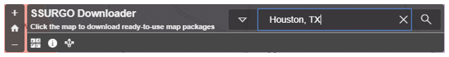
- In the search bar in the top corner, type "Houston, TX".
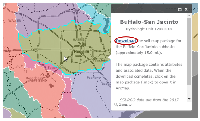
- Click in the Buffalo-San Jacinto subbasin to select it and click the Download link.
- Right-click on your downloaded BuffaloSanJacinto_12040104.ppkx file and select Show in folder. Copy the file.
- Navigate back to your HydrologyLab folder.
- Paste the BuffaloSanJacinto_12040104.ppkx file directly inside your HydrologyLab folder. Do NOT paste it inside the Hydrologylab.gdb geodatabase.
- Single Single-click the file .ppkx file to select it and press Enter.
A new ArcGIS Pro application window will open. You will complete Part 5 using this window
...
, but do not close your previous ArcGIS Pro window.
A map package packaged project file (.mpkppkx), contains both a map document project (.mxdaprx) and all data layers referenced by that map documentin the project in a project geodatabase (.gdb). The new instance of ArcGIS Pro will open showing the different soil classes within the subbasin.
- On In the Map tabContents pane, click the Explore button.
- In the Map Display, click on any of the soil classes.
By default, you will see all of the attributes of the top-most layer, which is currently the Subbregion (Subbasin) layer. In order to see the attributes of the Map Units (soils) layer:
- right-click the Subbasin layer and select Zoom To Layer.
- On the Map tab, click the Explore button.
- In the Contents pane, uncheck the Subbasin layer, so that it will not be queried in the next step.
- In the Map view
- In the ‘Explore’ drop down menu, select Selected in Contents
- Click Map Units layer in contents to select it.
- Again in the Map Display, click on any of the soil classes.
Scroll down through the list of fields to see the wide variety of data available for each soil class. You may need to scroll to the right to see the actual values stored in these fields. In particular, you will be utilizing the data stored in the Available Water Storage 0-100 cm – Weighted Average field.
...
You will now clip the soil polygons to the extent of the Buffalo-San Jacinto subbasin.
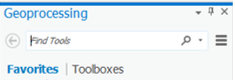
- On the Map tabribbon, click the Analysis tab and selectclick the Tools button.
- On the At the top of the Geoprocessing pane, in the 'Find Tools' search bar, type Clip "clip" and press Enter Enter.
- Click Click Clip Clip (Analysis Tools).
Read the ‘Clip’ window help and review the sample illustration. Notice that this tool clips one dataset to the extent, or shape, of another dataset.
- For ‘Input Features’, use the drop-down menu to select the Map Units layer.
- For ‘Clip Features’, use the drop-down menu to select the Subbasin layer.
Notice that Hover over the ‘Output Feature Class’ field and note that the file path did not default to your HydrologyLab geodatabase, but instead to the default geodatabase that was referenced in the map package you downloaded.
...