...
- In the Catalog pane on the right, expand the Databases folder.
- Expand the Projections.gdb geodatabase.
Since the MajorRoads layer is the only one that came from a local agency, it is most likely to have been provided in the ideal projection for this area. Since the map takes on the projection of the first layer that is added to it, we will be sure to add the MajorRoads layer first.
- Right-click the MajorRoads feature class and select Add to NewMap.
Now you can add any additional layers to your map.
- Click the County feature class to select it.
- Hold down Ctrl and click the Schools feature class, so that both feature classes are now selected.
- Right-click the Schools feature classes and select Add to CurrentCurrent Map.
Now you will investigate whether or not the coordinate systems of the data layers are defined.
- In the Contents pane on the left, double-click the MajorRoads layer name to open the 'Layer Properties' window.
- In On the left menu, click the Source tab.
- Scroll down and expand the Spatial Reference section.
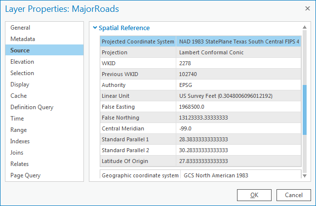
Under the ‘Spatial Reference’ section, scroll down and notice that both a geographic coordinate system and a projection are listed, which indicates that the coordinate system of this feature class has already been defined.
...
The general type of projection is Lambert Conformal Conic, but its properties (central meridian, standard parallels, latitude of origin, etc.) have been modified to be optimal for South Central Texas. These modifications are saved under the Projected Coordinate System name NAD 1983 StatePlane Texas South Central FIPS 4204 Feet. The State Plane projection system divides each state into multiple planes, or zones, following county boundaries that are suitable for mapping local regions within each state. Houston falls within the South Central plane in Texas.
- In the ‘Layer Properties: MajorRoads’ window, click Cancel.
- In the Contents pane, double-click the Schools layer name to open the 'Layer Properties' window.
- In On the left menu, ensure the Source tab is still selected and expand the Spatial Reference section.
Note that the Schools feature class uses the same geographic coordinate system as the MajorRoads feature class: GCS North American 1983. Even the general projection type is the same: Lambert Conformal Conic. However, its properties have been modified to be suitable for all of Texas, rather than just the South Central portion of Texas, so the Projected projected coordinate system name is now Texas Centric Mapping System/Lambert Conformal. The Texas Centric Mapping System is an example of a statewide projection that is suitable for mapping the entire state. Statewide projections are commonly developed for large or elongated states, such as Alaska, California, Michigan, and Texas, which would otherwise be divided into numerous small bands using the State Plane system.
...
Note that the spatial reference is in an Unknown Coordinate Systemunknown coordinate system, meaning that the coordinate system of this feature class has not been defined. In other words, ArcGIS does not know which coordinate system the data was originally created in and, therefore, will probably not be able to accurately line up this data layer with the other data layers. Before you can reliably use this feature class, you will need to define its coordinate system and projection.
...
The geographic coordinate system and projection for each of the three feature classes you investigated are summarized in the table below.
Layer | Geographic Coordinate System | Projected Coordinate System |
MajorRoads | NAD 1983 | State Plane Texas South Central |
| Schools | NAD 1983 | Texas Centric Mapping System |
County | Undefined | Undefined |
...
You will now see what happens when you attempt to add view an undefined layer to ArcGIS. The data frame, or display, in a map. As previously mentioned, the map takes on the coordinate system and projection of the first layer added to it. In this case, since the MajorRoads layer was the first layer added, you expect the data frame map will take on the State Plane Texas South Central projection. To verify this, you will check the coordinate system of the data framemap.
- At Near the top of the Contents pane, rightdouble-click Map and select Properties to open the 'Map Properties' window.
- In On the menu on the left, select click the Coordinate SystemsSystems tab.
Notice that, indeed, the State Plane Texas South Central projection is listed.
(insert image)
- In the ‘Map Properties: Map’ window, click Cancel.
- In the Contents pane, right-click the MajorRoads layer and select Zoom to Layer.
Notice that both the MajorRoads layer and the Schools layer appear to line up properly, even though they have different projections. This is because ArcGIS is able to perform “on-the-fly” projection, as long as the coordinate systems of both layers are defined. On-the-fly projection means that the Schools layer is being superficially displayed in the State Plane Texas South Central projection of the data frame, based on calculations performed by ArcGIS; however, the projection of the Schools feature class itself has not been altered from the Texas Centric Mapping System projection.
...