...
Now that all of your data has been defined, you can transform all the feature classes into a common projection. Unlike the process of defining data, where there is only one projection you can use (the one specified in the metadata), when projecting data, you can select whichever projection best suites your particular combination of data and tasks at handstudy area and research question measurement types. Since your data focuses on the Harris County Houston region, the State Plane Texas South Central projection would be suitable.
...
- At the top of the Geoprocessing pane, click the Back arrow.
- In the 'Find Tools' search bar, type ‘project’.
- Click the Project tool to open it.
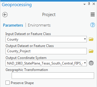
- For 'Input Dataset or Feature Class', use the drop-down menu to select the County layer.
Note that the output dataset is saved to the same geodatabase as the input dataset and the name of the output feature class has the suffix “_Project” tacked onto appended to the end of the original input feature class name to indicate which tool was used to produce that feature class.
- For ‘Output Coordinate System’, use the drop-down menu to select the MajorRoads layer.
Notice that the NAD 1983 State Plane Texas South Central projection has now been imported from the MajorRoads layer. While you could have again navigated to the projectionyourselfprojection yourself, in this case, you know that the same coordinate system is already used by the MajorRoads layer. In such an instance, it is easier to import the coordinate system from another layer, especially if you are not familiar with where the coordinate system of interest is stored in the overall hierarchy.
- Ensure that your Geoprocessing pane appears as shown below and click Run.
When previously defining a layer, you simply updated the metadata attached to that layer to include the known coordinate system and projection. When projecting a layer, you have actually created a second copy of the data in the new coordinate system. The original layer stays in the native coordinate system and the new layer is converted to the desired coordinate system.
- In the Catalog pane, rightdouble-click the County_Project and select Properties. Navigate layer name.
- On the left, ensure to the Source menu tab is still selected and expand the Spatial ReferenceReference section.
Note that the Geographic geographic coordinate system is still GCS North American 1983 and that the new coordinate system is NAD 1983 StatePlane Texas South Central FIPS 4204 Feet.
- In the ‘Feature Class Properties’ window, click Cancel. In the ‘Layer Properties: County_Project’ window, click Cancel.
You will now repeat the same process to re-project the Schools feature class from the Texas Statewide Mapping System projection into the State Plane Texas South Central projection.
- Repeat steps 3-7all steps in the 'Projecting Layers' section with the Schools layer. When your Geoprocessing pane looks like the one appears as shown below, select Run.

All of your layers have now been projected into the State Plane Texas South Central projection.
...